The Haecksen Map is becoming a staple in our community and it’s constantly evolving. At the 38th Chaos Communication Congress there was the first opportunity to introduce the project to a larger audience and to discuss it. Thanks to the dedicated support of the Haecksen network we could even show the map in various entirely different ways – analog and digitally.
Presentation of the current live version in the Assembly
So there was a display with the current live version right next to the Helpdesk in the Haecksen-Assembly, on which everybody could interact with it. Lots of people stopped by to look for a group in their region or to check out regular meetups. Some even took the opportunity to report new entries via the report button or updated existing records. Others just scrolled and clicked a little around the map app, because they were curious for OpenStreetMap, the functions or the technical implementation.
Analog Map to participate
Alongside this digital version there also was an analog map, where people could mark their location. For that we put a large map of the German Federal States under the headline “Where Haecksen haecksen” on a board and provided wobbly eye stickers. All Haecksen were invited to mark their hometown with a wobbly eye sticker. By the end of the event it was actually possible to determine some clusters:
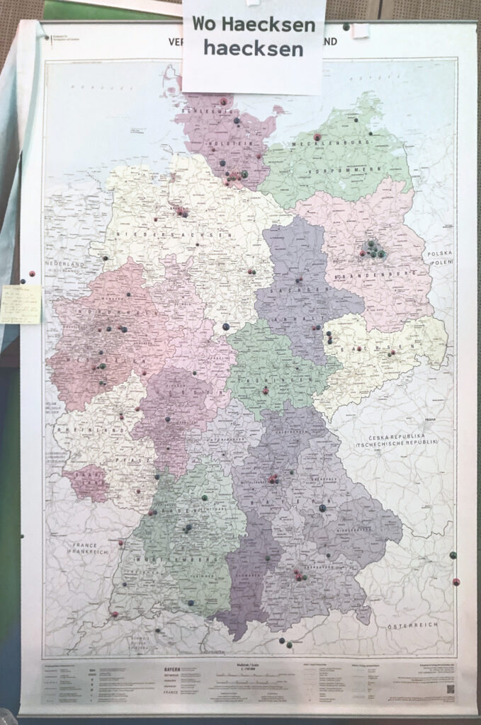
Many Congress visitors therefore were (unsurprisingly) from Hamburg and Berlin. But we also saw wobbly eyes pop up in neighboring countries, like eg the Netherlands or Austria.
The very first “Haecksen Count”
We were able to get an even more precise picture of where Haecksen are located by a Tablet-Version of the map, that also included all other countries. This version was provided locally on a loaned device, which we passed around at our well visited Haecksen Picnics. Participants could mark and save their location with the tablet version. The input was stored locally and we will be analyzing the data soon:
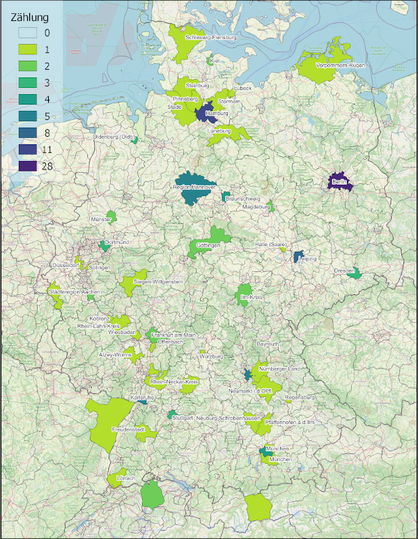
Our goal was to get a first-ever “Haecksen count”. Of course, this was just a small sample, since not all Haecksen were at the 38c3 and we couldn’t invite everyone at the Congress to participate. Still, we’re hoping for some new insights. Plus, it was a useful experiment. We hope the experience will help us improve the app and make it more useful.
Open questions discussed in a workshop
As we developed the map, we kept running into some fundamental questions that we couldn’t or didn’t want to answer on our own. After all, we want the Haecksen Map to be a tool that everyone likes and enjoys using.
Eg to let Haecksen connect with each other, we’d need to store some contact info. Meanwhile we don’t want to enforce anybody to reveal personal information (the map is finally a public tool). So how to achieve a proper balance of privacy and networking effect? How can the map support best the founding of local Haecksen initiatives while being economically with data?
To tackle these questions and get some feedback, we hosted a workshop on Day 1 of the Congress. During the workshop, we evaluated the map app together – and some bugs and improvement suggestions were collected.
Bottom line
When we first talked about creating such a map for the Haecksen community at the 2023 Chaos Communication Camp, we didn’t have a clue what we were getting ourselves into. That there’s finally a working version of the Haecksen Map we mainly owe to the great support of the Haecksen network.
Exactly like this we want to continue in 2025! Especially because the 38c3 edified us again, that we’re on the right track. It was exciting to see how appealing old and new Haecksen find the app. The need to improve the local networking is obviously large!
P.S.: If you’d want to support the map project or provide feedback, please reach out to us via Rocket #haecksenkarte or by email at haecksenkarte@haecksen.org!
Page Owner: Haecksenkarte